Thursday, May 1, 2014

Huế - Việt Nam

Huế nằm ở dải đất hẹp của miền Trung Việt Nam và là thành phố tỉnh lỵ của Thừa Thiên - Huế. Thành phố là trung tâm về nhiều mặt của miền Trung như văn hoá, chính trị, kinh tế, giáo dục, y tế, du lịch, khoa học kỹ thuật, đào tạo... 

Cầu Tràng-Tiền Huế  (Trang-Tien bridge)


Với dòng sông Hương và những di sản để lại của triều đại phong kiến, Huế, còn gọi là đất Thần Kinh hay xứ thơ, là một trong những thành phố được nhắc tới nhiều trong thơ văn và âm nhạc Việt Nam.  
Huế là đô thị cấp quốc gia của Việt Nam và cố đô của Việt Nam thời phong kiến dưới triều nhà Nguyễn (1802 - 1945). 

Huong river


Nằm tựa lưng vào dãy núi Trường Sơn, khu vực thành phố Huế là đồng bằng thuộc vùng hạ lưu sông Hương và sông Bồ, có độ cao trung bình khoảng 3 – 4 m so với mực nước biển và thường bị ngập lụt khi đầu nguồn của sông Hương (trên Dãy Trường Sơn) xảy ra mưa vừa và lớn. 

Khu vực đồng bằng này tương đối bằng phẳng, tuy trong đó có xen kẽ một số đồi, núi thấp như núi Ngự Bình, Vọng Cảnh...

Diện tích tự nhiên 71,68 km2, dân số năm 2012 ước là 344.581 người. 

Thành phố Huế có sự ngoại lệ về khí hậu so với vùng Bắc Bộ và Nam Bộ, vì nơi đây khí hậu khắc nghiệt và có sự khác nhau giữa các miền và khu vực trong toàn tỉnh. Vùng duyên hải và đồng bằng có hai mùa rõ rệt: mùa khô từ tháng 3 đến tháng 8, trời nóng và oi bức, có lúc lên tới 39,9 °C. Từ tháng 8 đến tháng 1 là mùa mưa và hay xảy ra bão lụt, nhiệt độ trung bình 19,7 °C, cũng có khi hạ xuống còn 8,8 °C, trời lạnh. Vào mùa này có những đợt mưa suốt ngày, kéo dài cả tuần lễ. Vùng núi mưa nhiều, khí hậu mát mẻ, nhiệt độ dao động từ 9 °C đến 29 °C.

Ngọ Môn


Thuận Hóa - Phú Xuân -Huế có một quá trình lịch sử hình thành và phát triển khoảng gần 7 thế kỷ (tính từ năm 1306). Trong khoảng thời gian khá dài ấy Huế đã tích hợp được những giá trị vật chất và tinh thần quý báu để tạo nên một truyền thống văn hóa Huế. Truyền thống ấy vừa mang tính đặc thù - bản địa của một vùng đất, không tách rời những đặc điểm chung của truyền thống văn hóa dân tộc Việt Nam; trong tiến trình hình thành văn hóa Huế có sự tác động của văn hóa Đông Sơn do các lớp cư dân từ phía Bắc mang vào trước thế kỷ 2 và sau thế kỷ 13 hỗn dung với thành phần văn hóa Sa Huỳnh tạo nên nền văn hóa Việt - Chăm. Trong quá trình phát triển, chuyển biến có ảnh hưởng của các luồng văn hóa khác các nước trong khu vực Đông Nam Á, Trung Quốc, Ấn Độ, phương Tây... 

Cidadela de Hué


Văn hóa Huế được tạo nên bởi sự đặc sắc về tinh thần, đa dạng về loại hình, phong phú và độc đáo về nội dung, được thể hiện rất phong phú trên nhiều lĩnh vực như: văn học, âm nhạc, sân khấu, mỹ thuật, phong tục tập quán, lễ hội, lề lối ứng xử, ăn - mặc - ở, phong cách giao tiếp, phong cách sống...

 Buddhist Temple in Hue, Vietnam


Kiến trúc ở Huế phong phú và đa dạng: có kiến trúc cung đình và kiến trúc dân gian, kiến trúc tôn giáo và kiến trúc đền miếu, kiến trúc truyền thống và kiến trúc hiện đại...Những công trình kiến trúc công phu, đồ sộ nhất chính là Quần thể di tích Cố đô Huế hay Quần thể di tích Huế. Đó là những di tích lịch sử - văn hóa do triều Nguyễn chủ trương xây dựng trong khoảng thời gian từ đầu thế kỷ 19 đến nửa đầu thế kỷ 20 trên địa bàn kinh đô Huế xưa; nay thuộc phạm vi thành phố Huế và một vài vùng phụ cận thuộc tỉnh Thừa Thiên-Huế, Việt Nam.

Hue. Mausoleo Khai Dinh (8) 08.12.2010


Có hai loại lễ hội: lễ hội cung đình và lễ hội dân gian. Lễ hội cung đình phản ánh sinh hoạt lễ nghi của triều Nguyễn, phần lớn chỉ chú trọng về "lễ" hơn "hội". Lễ hội dân gian gồm nhiều loại rất phong phú, tiêu biểu như: lễ hội Huệ Nam ở điện Hòn Chén hay còn gọi là lễ rước sắc nữ thần Thiên y A na theo tín ngưỡng của người Chăm pa, lễ hội tưởng niệm các vị khai sinh các ngành nghề truyền thống, lễ hội tưởng nhớ các vị khai canh thành lập làng. Trong những dịp tế lễ, nhiều sinh hoạt văn hóa bổ ích như đua thuyền, kéo co, đấu vật... còn được tổ chức và thu hút đông người xem.

Huế còn lưu giữ trên 1000 món ăn nấu theo lối Huế, có cả những món ăn ngự thiện của các vua triều Nguyễn. Bản thực đơn ngự thiện có trên vài chục món thuộc loại cao lương mỹ vị, được chuẩn bị và tổ chức rất công phu, tỷ mỷ, cầu kỳ. Các món ăn dân dã rất phổ biến trong quần chúng với bản thực đơn phong phú hàng trăm món được chế biến khéo léo, hương vị quyến rũ, màu sắc hấp dẫn, coi trọng phần chất hơn lượng; nghệ thuật bày biện các món ăn đẹp mắt, nghệ thuật thưởng thức tinh tế.

 Ẩm thực Huế


Ca Huế là một hệ thống bài bản phong phú gồm khoảng 60 tác phẩm thanh nhạc và khí nhạc theo hai điệu thức lớn là điệu Bắc, điệu Nam và một hệ thống "hơi" diễn tả nhiều sắc thái tình cảm đặc trưng. Điệu Bắc gồm những bài ca mang âm điệu tươi tắn, trang trọng. Điệu Nam là những bài âm điệu buồn, nỉ non, ai oán. Bài bản Ca Huế có cấu trúc chặt chẽ, nghiêm ngặt, trải qua quá trình phát triển lâu dài đã trở thành nhạc cổ điển hoàn chỉnh, mang nhiều yếu tố "chuyên nghiệp" bác học về cấu trúc, ca từ và phong cách biểu diễn. Đi liền với ca Huế là dàn nhạc Huế với bộ ngũ tuyệt Tranh, Tỳ, Nhị, Nguyệt, Tam, xen với Bầu, Sáo và bộ gõ trống Huế, sanh loan, sanh tiền. Kỹ thuật đàn và hát Ca Huế đặc biệt tinh tế nhưng Ca Huế lại mang đậm sắc thái địa phương, phát sinh từ tiếng nói, giọng nói của người Huế nên gần gũi với Hò Huế, Lý Huế; là chiếc cầu nối giữa nhạc cung đình và âm nhạc dân gian.

 Ca Huế trên sông Hương

Danh lam thắng cảnh: Núi Ngự Bình, Ðồi Vọng Cảnh, Núi Bạch Mã, Sông Hương, Bãi biển Thuận An, Bãi biển Lăng Cô, Bãi biển Cảnh Dương, Phá Tam Giang, Văn Miếu, Ðiện Hòn Chén, Cầu Ngói Thanh Toàn, Trường Quốc Học, Ðan viện Biển Ðức Thiên An, Chùa Thiên Mụ, Chùa Diệu Ðế, Chùa Từ Ðàm, Chùa Từ Hiếu, Nhà thờ dòng Chúa Cứu Thế, Thánh đường chính toà Phủ Cam.


Nguồn - http://vi.wikipedia.org/wiki/Hu%E1%BA%BF

Sunday, November 17, 2013

Toronto - Canada

Toronto is the largest city in Canada and the provincial capital of Ontario. It is located in Southern Ontario on the northwestern shore of Lake Ontario. The history of Toronto began in the late 18th century when the British Crown purchased its land from the Mississaugas of the New Credit. The British established a settlement there, called the Town of York, which its lieutenant governorJohn Graves Simcoe, designated as the capital of Upper Canada. The city was ransacked in the Battle of York during the War of 1812. In 1834, York was incorporated as a city and renamed Toronto. It was damaged in two huge fires, in 1849 and 1904. Over the years, Toronto has several times expanded its borders through amalgamation with surrounding municipalities, most recently in 1998...


Toronto has a humid continental climate, with warm, humid summers and cold winters. The city experiences four distinct seasons, with considerable variance in day to day temperature, particularly during the colder weather season. Owing to urbanization and its proximity to water, Toronto has a fairly low diurnal temperature range (day-night temperature difference). The denser urban scape makes for warmer nights year around and is not as cold throughout the winter than surrounding areas (particularly north of the city); however, it can be noticeably cooler on many spring and early summer afternoons under the influence of a lake breeze.


Following the Second World War, refugees from war-torn Europe and Chinese job-seekers arrived, as well as construction labourers, particularly from Italy and Portugal. Following the elimination of racially based immigration policies by the late 1960s, immigration began from all parts of the world. Toronto's population grew to more than one million in 1951 when large-scale suburbanization began, and doubled to two million by 1971. By the 1980s, Toronto had surpassed Montreal as Canada's most populous city and the chief economic hub. Click to Read more


 Toronto Photo Tour

More Travel by Video:

Venice - Italy

Venice, the world's only pedestrian city, is easily walkable, and the absence of cars makes this a particularly pleasant experience. However, walking and standing all day can also be exhausting, so it is best to pace yourself. The Rialtine islands - the 'main' part of Venice - are small enough to walk from one end to the other in about an hour, provided you don't get lost (a common occurrence).


The Most Serene Republic of Venice dates back to 827, when a Byzantine Duke moved its seat to what is now known as the Rialto, and for the following 970 years, prospered on trade and under the rule of a Roman-style Senate headed by the Doge. In 1797, the city was conquered by Napoleon, a blow from which it never recovered. The city was soon merged into Austria-Hungary, then ping-ponged back and forth between Austria and a nascent Italy, but Venice is still a monument to the glory days of the Renaissance, and historical culture still throbs powerfully in the old Italians' veins.

venice-gondola

Acqua alta (high water) has become a fact of life in Venice. The lagoon water level occasionally rises above the level of the squares and streets, flooding them. This can happen several times a year, at irregular intervals, usually in the colder months. Acqua alta usually lasts a few hours and coincides with high tide. You'll see raised walkways in side alleys ready to be pulled out when acqua alta hits. When the city begins to flood, sirens will sound to warn residents and businesses. If you speak fluent Italian, tune into news programs since their predictions of the times the flood begins and ends are usually on the spot. Normally, the tide rises and falls in six-hour cycles.
Click to Read more


 Street view

Saturday, August 31, 2013

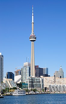
CN Tower - Toronto - Canada


The CN Tower (French: Tour CN) is a 553.33 m-high (1,815.4 ft) concrete communications and observation tower in Downtown Toronto, Ontario, Canada. Built on the former Railway Lands, it was completed in 1976, becoming the world's tallest free-standing structure and world's tallest tower at the time. It held both records for 34 years until the completion of Burj Khalifa and Canton Tower in 2010. It remains the tallest free-standing structure in the Western Hemisphere, a signature icon of Toronto's skyline, and a symbol of Canada, attracting more than two million international visitors annually. Its name "CN" originally referred to Canadian National, the railway company that built the tower. Following the railway's decision to divest non-core freight railway assets, prior to the company's privatization in 1995, it transferred the tower to the Canada Lands Company, a federal Crown corporation responsible for real estate development. Since the name CN Tower became common in daily usage, the abbreviation was eventually expanded to Canadian National Tower or Canada's National Tower. However, neither of these names is commonly used. In 1995, the CN Tower was declared one of the modern Seven Wonders of the World by the American Society of Civil Engineers. It also belongs to the World Federation of Great Towers, where it holds second-place ranking.


More Travel by Video:

30,000 Islands Ontario - Canada


Parry Sound is a town in Northern Ontario, Canada, located on the eastern shore of Georgian Bay. Parry Sound is located 160 km (99 mi) south of Sudbury and 225 km (140 mi) north of Toronto. It is the seat of Parry Sound District, a popular cottage country region for Southern Ontario residents. It also has the world's deepest natural freshwater port. The Parry Sound coastline is home to the Georgian Bay Biosphere Reserve, one of only 13 UNESCO sites in Canada. The eastern coast of Georgian Bay where Parry Sound is located is known as the "30,000 Islands" and is considered the world's largest freshwater archipelago. It covers 347,000 hectares of shoreline ecosystem, and over 100 species of animals and plants that are at risk in Canada and Ontario, including unique reptiles and amphibians. Sightseeing tours of the 30,000 Islands are offered by Georgian Bay Airways, and the Island Queen and MV Chippawa cruise ships. The area is also home to White Squall Outfitters, a sport outfitter which offers kayak and canoe rentals and tours during the summer, as well as winter sporting gear rentals during the winter.


More Travel by Video:

1000 Islands St. Ontario - Canada


The Thousand Islands constitute an archipelago of 1,864 islands that straddles the Canada-U.S. border in the Saint Lawrence River as it emerges from the northeast corner of Lake Ontario. They stretch for about 50 miles (80 km) downstream from Kingston, Ontario. The Canadian islands are in the province of Ontario, the U.S. islands in the state of New York. The 1,864 islands range in size from over 40 square miles (100 km2) to smaller islands occupied by a single residence, or uninhabited outcroppings of rocks that are only home to migratory waterfowl. To count as one of the Thousand Islands these minimum criteria had to be met: 1) Above water level year round; 2) Have an area greater than 1 square foot (0.093 m2); and 3) Support at least one living tree.


More Travel by Video:


Niagara Falls - Helicopters Ride

Niagara Falls

Born around 12,000 years ago, Niagara Falls is a set of massive waterfalls located on the Niagara River, on the border between Canada and the United States. The Falls are comprised of three separate waterfalls: the Horseshoe Falls, the American Falls, and the smaller, adjacent Bridal Veil Falls.  The crescent-shaped Horseshoe Falls is also known as the Canadian Falls as it is located mostly on the Canadian side of the border.


More Travel by Video: